
How an Aerial Photography Service Supports Developers and City Planners
 New York City is constantly building, expanding, and renovating. Every project, from high-rise towers to community centers, requires clear communication and accurate visuals. An aerial photography service gives developers, architects, and planners a perspective that traditional ground-level photos cannot provide. These images are not only useful for marketing but also for planning, documenting, and presenting projects to stakeholders.
Pre-Construction Applications
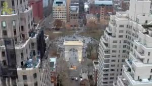
Before a single foundation is poured, aerial photography offers valuable insight. Developers often need to understand how a site fits into its neighborhood. Drone-based aerial imaging allows teams to capture land conditions, boundaries, and existing infrastructure quickly and accurately.
These visuals help with planning access points, studying shadows from nearby buildings, and reviewing the relationship between the site and surrounding streets. They can also serve as a baseline record of the land before construction begins. For city planners, these images provide context for zoning discussions and neighborhood impact studies.
Construction Monitoring
Once work starts, tracking progress becomes critical. An aerial photography service makes it possible to document changes week by week or month by month. This ongoing record helps contractors verify timelines and gives investors confidence in how a project is moving forward.
Drone imagery can also play a role in compliance. Visual records support safety checks, confirm adherence to permits, and provide documentation for insurance purposes. By reducing the need for scaffolding or manned inspections, aerial images save time and lower risk.
Marketing Real Estate Projects
Marketing is often just as important as building. Developers and real estate agents rely on strong visuals to attract interest long before a project is finished. Aerial photography creates stunning images for brochures, websites, and ads that highlight a property’s location, scale, and amenities.
For residential projects, these images can showcase proximity to parks, schools, and public transit. For commercial spaces, aerial shots highlight parking, traffic flow, and visibility from key routes. In crowded markets like New York, compelling aerial views can set a listing apart and speed up lease or sales efforts.
City and Community Benefits
 Aerial photography is not only a tool for developers. Cities and community groups also benefit from this technology. For zoning boards and planning commissions, drone images help visualize how a new project fits into the existing landscape. At public meetings, these images allow residents to see the scale of a development and understand its impact on their neighborhood.
Cultural institutions, nonprofits, and community organizations can also use aerial visuals to advocate for projects, showcase improvements, or highlight public amenities. By presenting accurate and clear images, these groups make discussions more transparent and productive.
Xizmo Media’s Edge
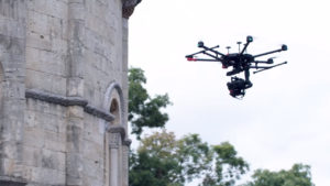
Not every aerial photography provider can handle the unique challenges of New York City. The dense environment, restricted airspace, and strict permitting requirements make it essential to work with an experienced team. At Xizmo Media, we bring both the technical and creative sides of aerial photography to every project.
Our FAA-certified pilots know how to navigate local regulations while still capturing the shots developers and planners need. We build tailored flight plans for each project, balancing safety, compliance, and creativity. With high-resolution equipment and a team that understands both production and technical requirements, we deliver images that support planning, monitoring, and promotion.
Building Smarter With Aerial Photography
The role of aerial visuals in New York City development continues to grow. An aerial photography service is no longer just a marketing tool—it is a resource for planning, compliance, investor communication, and community engagement. At Xizmo Media, we provide the expertise, technology, and local knowledge needed to make aerial photography practical and impactful for any project.
If you are a developer, planner, or real estate professional looking to strengthen your work with accurate and engaging visuals, our team is here to help. Reach out to Xizmo Media to discuss how aerial photography can support your next project.